SEE THE FUTURE IN EVERY ACRE
Remote sensing and geospatial intelligence to reveal the full potential of your land.

TURN LAND INTO OPPORTUNITY
AZULTERA MISSION
Azultera uses advanced remote sensing and geospatial analysis to reveal opportunities that may not be obvious from the ground—helping landowners and partners better understand the resources, conditions, and potential within their property.
By combining hyperspectral imaging, LiDAR, thermal sensing, terrain analysis, GIS, and field intelligence, we turn complex spatial data into actionable information for mineral exploration, water resources, energy potential, land management, and development decisions.
HYPERSPECTRAL IMAGING
Advanced spectral analysis identifies chemical signatures and differences in surface materials that are invisible to the human eye.
Hyperspectral data can reveal hidden mineral deposits and alteration zones, uncover vegetation growth, type, and stress, and show other land characteristics like hidden moisture and water sources.
With this data, Azultera turns spectral information into actionable spatial intelligence.


LiDAR, THERMAL & REMOTE SENSING
LiDAR exposes the terrain intelligence—slope, drainage, structure, access, and subtle landforms—that conventional imagery can miss.
Thermal imagery identifies springs, geothermal activity, and wildlife patterns.
Magnetometry uncovers magnetic anomalies associated with geology, buried features, and certain mineralized systems.
Azultera uses a suite of remote sensing tools to analyze every facet of value of land.
Where others see dirt, we see potential.
LAND INTELLIGENCE + INFRASTRUCTURE
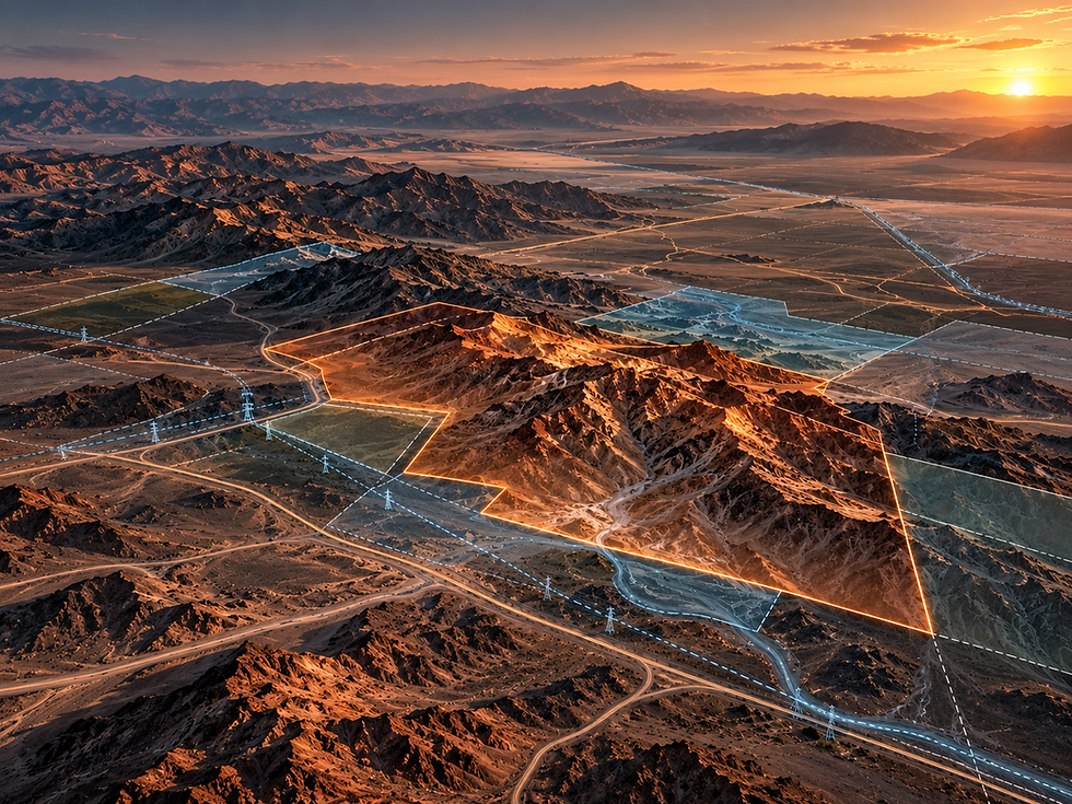
Remote sensing is only part of the picture. Azultera integrates spatial data with the physical, legal, and operational realities of a property to understand how the land can be used.
We map and evaluate features such as mining claims, property boundaries, roads and access, fence lines, power infrastructure, pipelines, water features, neighboring parcels, existing development, and other site conditions that may affect a property's potential.
By bringing these layers together with terrain, spectral, thermal, and other remote-sensing data, Azultera creates a more complete picture of the land—helping identify opportunities, limitations, and the highest-value paths forward.

03 MINERAL EXPLORATION
Mineral deposit signatures, structural trends, and terrain relationships are integrated through remote sensing and geospatial analysis to target prospective ground.

02 RANCH & LAND IMPROVEMENT
Integrated land intelligence reveals infrastructure, access, water, rights-of-way, and property relationships that shape operational and development potential.

01 MINING CLAIM INTELLIGENCE
Historical research and geospatial mapping to reconstruct legacy mining claims, land status, access, and surrounding property relationships.
LAND INTELLIGENCE IN ACTION
SELECTED APPLICATIONS
BUILT FROM EXPERIENCE ON THE LAND
ABOUT US

Lt Col (Ret) Kevin Key
PRESIDENT
Kevin Key is a retired U.S. Army Lieutenant Colonel with 24 years of operational leadership across Army Special Operations and airborne forces, including service with the 75th Ranger Regiment, Army Special Forces, and the 82nd Airborne Division. His career centered on complex operations, logistics, resource management, and decision-making in demanding environments.
He also holds an M.S. in Defense Analysis, with training in operational planning, network modeling, resource allocation, and systems integration.
A third-generation Western cattle rancher, Kevin brings deep practical experience in land stewardship and large-scale ranch operations near Elko, Nevada—grounding Azultera’s technology and analysis in the realities of how land is actually managed, accessed, and used.
Noel Heiks
VICE PRESIDENT
Noel Heiks is a technology founder, aerospace executive, and research engineer with more than 25 years of experience developing and leading advanced sensing and unmanned systems programs. Her background includes executive leadership in long-range unmanned aircraft, satellite remote sensing, automated inspection, and the development of optical, RF, chemical, and other sensing technologies for defense and commercial applications.
She holds a B.S. in Physics and an M.S. in Electrical Engineering, is an FAA Part 107 commercial drone pilot, and is pursuing Professional Land Surveying licensure in Nevada.
At Azultera, Noel leads remote sensing, UAS, GIS, and geospatial analysis—integrating advanced sensing technologies with terrain, property, and resource data to turn complex spatial information into actionable land intelligence.

Azultera combines operational experience, land stewardship, and advanced geospatial technology to uncover the full potential of land.
SEE THE OPPORTUNITY.
MAP THE PATH FORWARD.
Azultera works with agencies, infrastructure operators, mining and energy companies, landowners, and strategic partners to evaluate complex land, resource, and development challenges. Whether the project involves mineral exploration, infrastructure planning, energy development, remote sensing, or large-scale land intelligence, we bring together the data, technology, and operational perspective needed to move from uncertainty to actionable opportunity.
GENERAL INQUIRIES
info@azultera.com
OPERATIONS HUB
Elko County, Nevada